The 1931 Katoomba Landslide — The Collapse of Dog Face Rock
In 1931, a massive landslide destroyed Dog Face Rock above the Jamison Valley at Katoomba in the Blue Mountains. Across several major collapses, hundreds of thousands of cubic metres of sandstone fell into the valley below, permanently changing one of the Blue Mountains’ most recognisable cliff formations. Nearly a century later, the scar is still there.
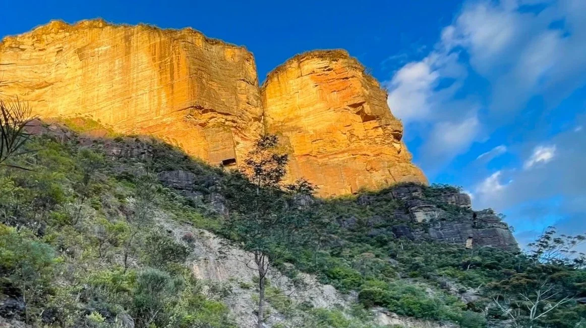
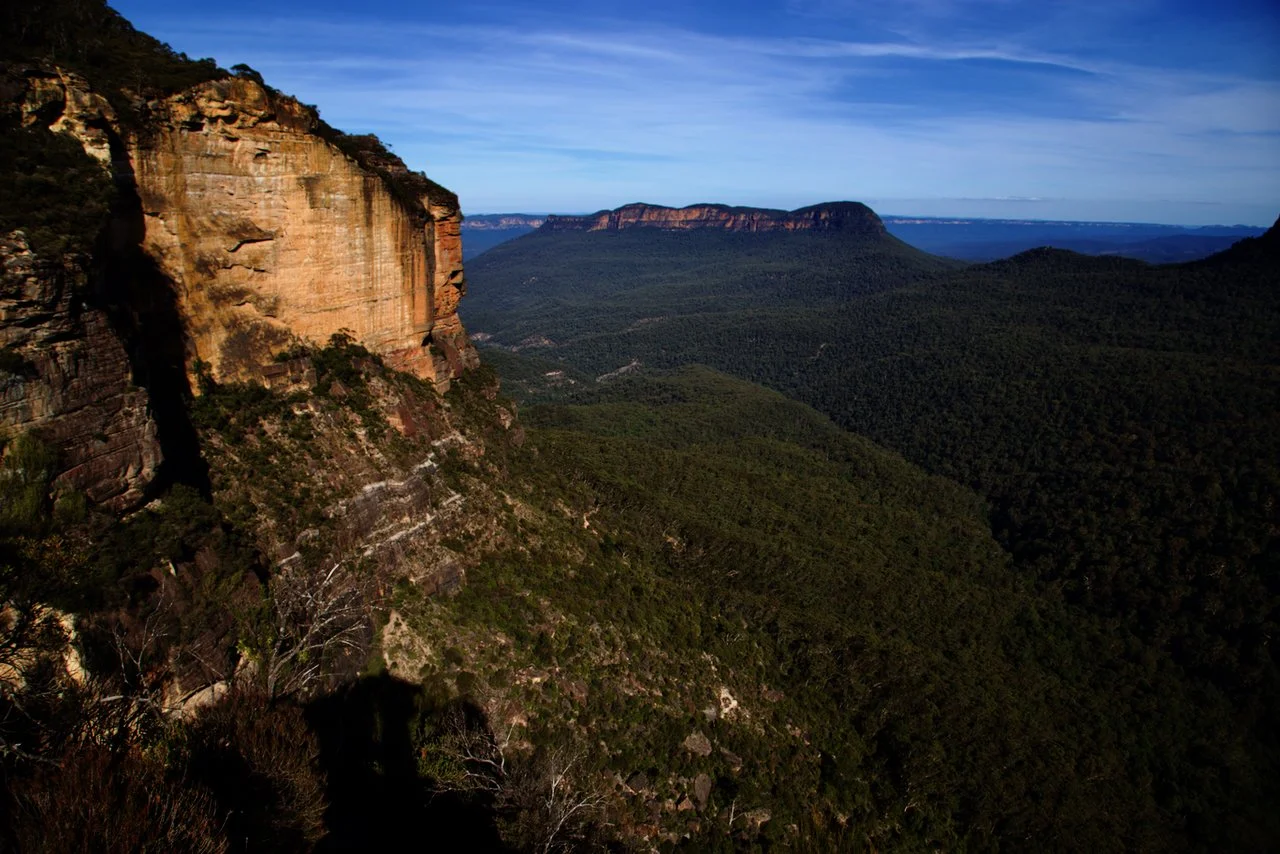
The landslide scar, catching the last light of the day. Image: Sandstone Symphony (2021)
Along the escarpment above the Jamison Valley, much of the cliffline appears unchanged — weathered, darkened, and continuous. Nothing stands out at first.
But in 1931, one section began to open. A fissure formed behind the edge, deepening and widening, running parallel to the escarpment. For months, the rock held. Then it began to fall.
Dog Face Rock — a distinct sandstone projection — collapsed into the Jamison Valley in a series of failures that drew crowds, unsettled the town, and permanently altered both the cliff and the valley below.
Today, the change is still there — if you know where to look.
This is Katoomba Landslide, or simply, The Landslide.
What Was Dog Face Rock?
Before 1931, Dog Face Rock was one of the many named features along the Katoomba escarpment.
It projected outward from the cliff at the upper reaches of Pitts Amphitheatre, its profile recognisable enough to be named.
Now it is gone — only a section of cliff where it once stood.

A fissure opens
In late 1930, a coal miner named Arthur Mellor reported a large fissure opening in the ground behind Dog Face Rock, near the edge of the escarpment.
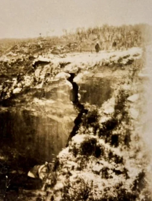
It was described as up to eight to ten feet wide and extending for some distance parallel to the cliff. Visitors could approach it and look directly down into it. Photographs show a narrow, sheer opening — already deep and clean-sided.
Surveyors estimated its depth at up to 400 feet. The nearby Katoomba Colliery was quickly implicated, with some attributing the movement to underground mining.
Small rock falls began to occur.
By the new year, the crack was widening steadily — not a sudden break, but a progressive failure already underway. Contemporary reports described “a mighty cliff… expected hourly to give way,” the fissure already widening behind the escarpment.
The cliff had begun to separate from the plateau behind it.

The fissure widens. (Manning, A. A Landslide, Katoomba. Blue Mountains City Library, Local Studies Collection)
Waiting
People came to watch. The fissure became an attraction. Visitors travelled from Sydney, and crowds gathered at the cliff edge to look into the crack and wait.
Katoomba is waiting with some trepidation,” one report noted.
Weeks passed. Then months.
There were minor rockfalls — enough to confirm instability, but not enough to complete the collapse.
The cliff held, visibly fractured.

Crowds gathered to watch the crack widen — “a mighty cliff… expected hourly to give way.”
Fairfax Corporation. (1931). Cliff landslide at Katoomba, New South Wales, ca. 1931, 1 Retrieved May 3, 2026, from http://nla.gov.au/nla.obj-157546227
The collapse
The collapse did not occur all at once.
The first major fall came on the evening of 28 January 1931, when the southern side of Dog Face Rock gave way. Further failures followed through the night, including another large collapse several hours later. By the early hours of 29 January, a substantial section of the northern cliff had fallen, with the noise and vibration strong enough to be felt across Katoomba.
There was still a large mass of rock left standing — a fractured remnant above the valley. Crowds continued to gather, waiting for the final collapse.
It did not come immediately. Months passed before the central mass — described at the time as the “leaning rock” — finally gave way in May. A further collapse in June removed remaining sections of the detachment zone.
Across these events, on the order of tens of thousands of cubic metres of sandstone were dislodged, reshaping both the cliff face and the valley below.
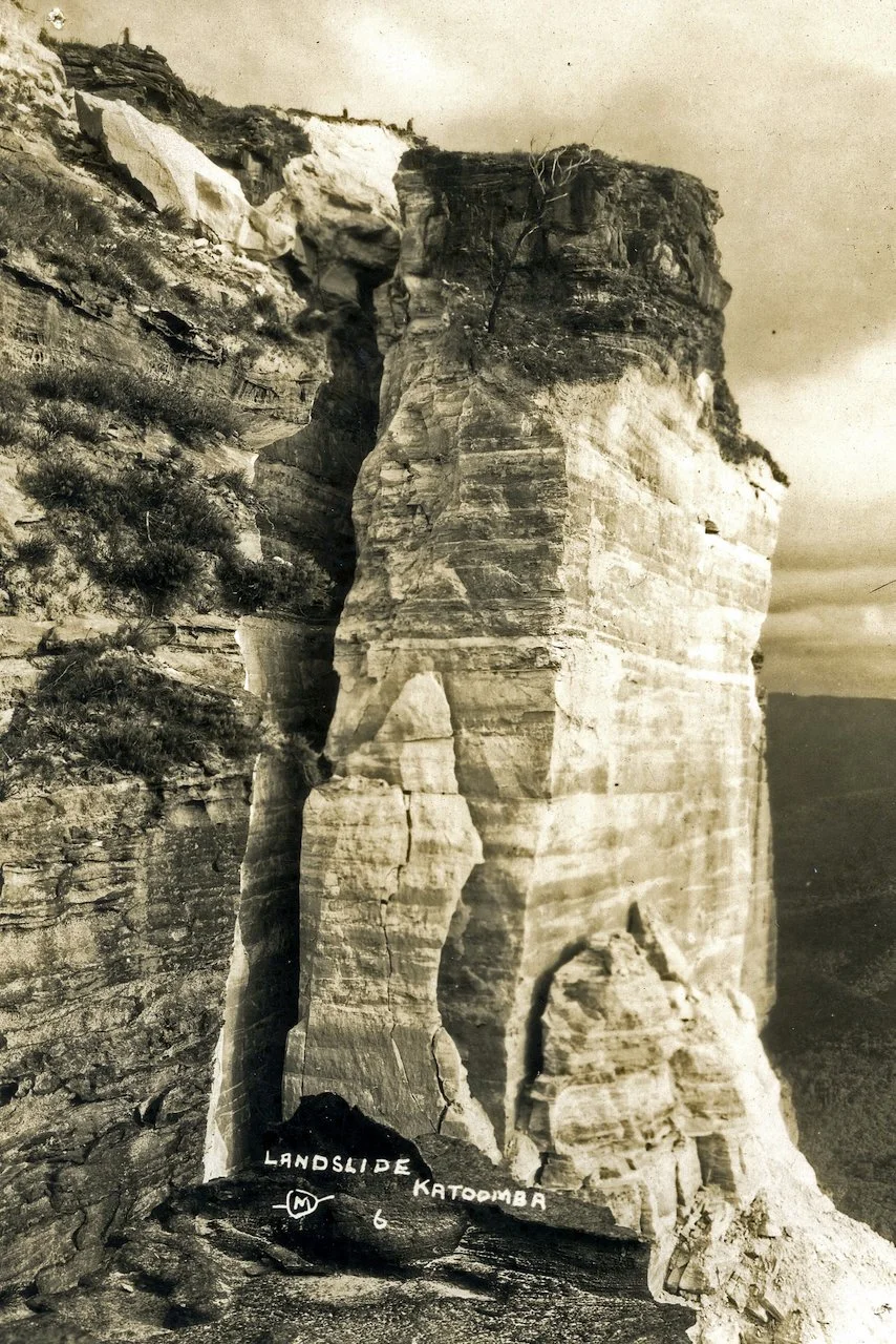
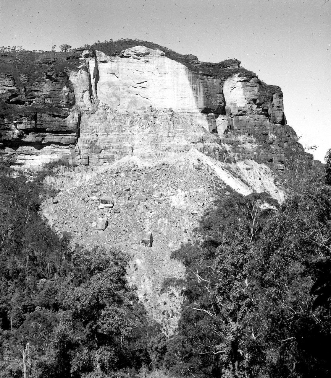
What remained was no longer a projecting formation, but a newly exposed cliff face — raw, angular, and sharply defined against the older, weathered rock around it.
Why it happened
The collapse was not attributed to a single cause.
Underground coal mining beneath the escarpment — at the Katoomba Colliery — likely reduced support within the rock mass. The mine was worked using a system where blocks of coal, known as pillars, were left in place to support the rock above. Later removal of these pillars would have reduced that support, allowing the rock mass above the mine to begin to deform.
Water infiltration likely also have played a role, softening underlying layers and reducing cohesion along bedding planes.
The sandstone is naturally jointed, divided by vertical fractures that can isolate large blocks. Once separation begins along these joints, failure can proceed progressively.
The collapse followed the structure already present in the rock.
Scientific context
More recent analysis provides a clearer picture of how the failure developed.
A detailed study by Tuckey (2023) confirms the Dogface Rock landslide as a progressive, mining-induced failure, rather than a single sudden collapse. As he notes, “the failures were progressive and multi-stage.” Extraction of coal pillars beneath the escarpment altered the stress within the rock mass, initiating a period of instability that unfolded over months. A tension crack opened along the cliff top in late 1930 and continued to widen and deepen, accompanied by minor rockfalls and audible cracking.
The study shows that the failure developed through progressive brittle fracture. Stress changes caused the rock to deform in tension, generating cracks that propagated upward from depth and linked with existing joints in the sandstone. Over time, these fractures coalesced into a continuous failure surface.
When collapse finally occurred, it did so in stages. Large sandstone slabs detached and toppled outward before breaking apart and running down the slope. The cliff did not simply slide — it fractured, lost cohesion, and then failed.
After the fall
In the immediate aftermath, the change was obvious.
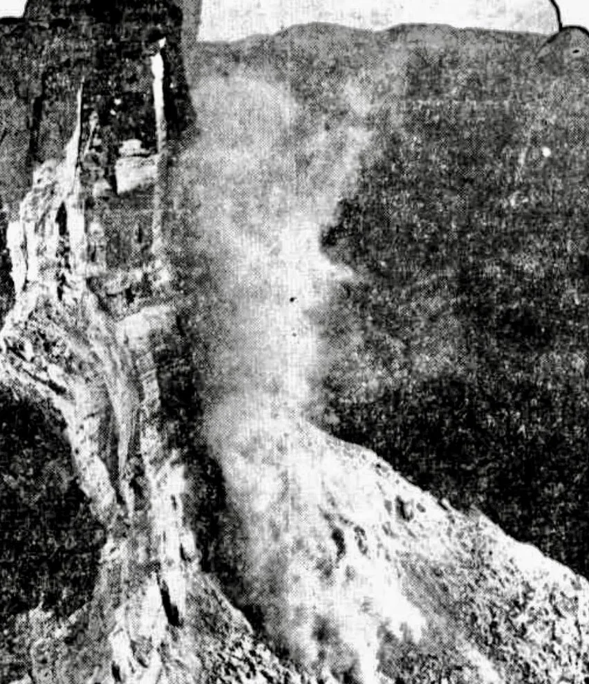
Photographs from 1931 show a pale, freshly exposed cliff face, sharply defined against the darker escarpment. Debris lay across the valley floor below.
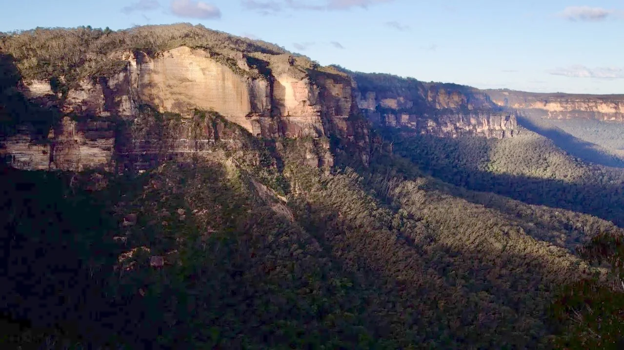
Today, those features remain. The exposed face is still lighter than the surrounding rock — a broad, clean surface. Even after decades of weathering, it appears newer, and in angled light catches the setting sun and glows against the darker cliff.
Below the cliff, the talus slope persists as a clearly defined spread of broken rock. Vegetation has returned, but only as scrub. The full forest has not reclaimed it.
Further falls occurred in January 1951 following persistent rain. 200 yards of the path across the landslide was destroyed and a 60 ton boulder shifted hundreds of yards further into the valley.
Photographed several years after the collapses, a path is already evident across the debris field. (Unknown Photographer The Landslide, Katoomba. Blue Mountains City Library)
The Landslide today
From Cliff Drive above the escarpment, the cliff face is largely hidden. Landslide Lookout, despite its name, offers little view of the site.
The clearest views are from Narrow Neck or Federal Pass between the Golden Stairs and Scenic World, looking up at the escarpment. Walkers could traverse the Landslide along Federal Pass and also visit nearby Katoomba Falls on the same day.
From these positions, the pale face stands out against the darker cliff, and after a nearly a century, the scrubby slope below reads differently from the older surrounding bush.
In angled light, the face catches the setting sun and glows. From some angles, the change is immediate. From others, it almost disappears.


Recent landslides in the Blue Mountains
In recent years, landslides have been recurring features of the Blue Mountains landscape.
Carne Wall — Grose Valley (August 2025)
A large rockfall, ~200,000 m³, collapsed from Carne Wall near Point Pilcher after prolonged wet conditions—one of the most substantial recent failures in the upper Grose.
Wentworth Falls — Jamison Valley (July 2022)
A landslide across a walking track near Wentworth Falls resulted in fatalities.
Lockleys Pylon — Grose Valley access (circa 2021)
A cliff fall from below Lockley’s Pylon into Fortress Creek that can be seen from Fortress Ridge and Fortress Creek Falls. See our Fortress Creek Falls journal article .
Golden Stairs — repeated closures (recent years)
Repeated landslides and slope instability have led to repeated closures.
Mount Solitary — southern flanks (ongoing)
Aerial photography shows large rock falls and extensive debris flow from the south western side of Mount Solitary.
Blue Mountains — widespread landslips (2022–2024)
Successive wet years triggered dozens of smaller failures that severely affected tracks and roads across the region including access to the Megalong and Wolgan Valleys.
References and further reading
Trove
Contemporary newspaper reports on the 1931 Katoomba landslide, including:
“Huge Landslide Imminent”, Evening News, 26 January 1931
“Katoomba Landslide”, The Sydney Morning Herald, 29 January 1931
“The Landslide”, The Sydney Morning Herald, 4 May 1931State Library of New South Wales
Archival photographs of the Katoomba escarpment before and after the collapseBlue Mountains Library
Local historical material relating to the 1931 landslidesCameron-Smith, B. (2019). The leaning rock of Katoomba: Tragedy of nature or man-made landslide?
Fox, Brian & Keats, Michael, 1940- & Fox, John. (2018). Blue Mountains Geographical Encyclopaedia, St Ives, NSW: Keats Holdings Pty Ltd https://www.bushexplorers.com.au/catalog/bmge1
Webber, C. F. (2023). Mountains mishaps: Death and misadventure in the NSW Blue Mountains. Carmarthen Highlands Press.
Tuckey, Z. (2023). The role of progressive brittle fracture in the 1931 landslide at Dogface Rock, Katoomba. Australian Geomechanics Journal, 58(3), 77–93. https://doi.org/10.56295/AGJ5833